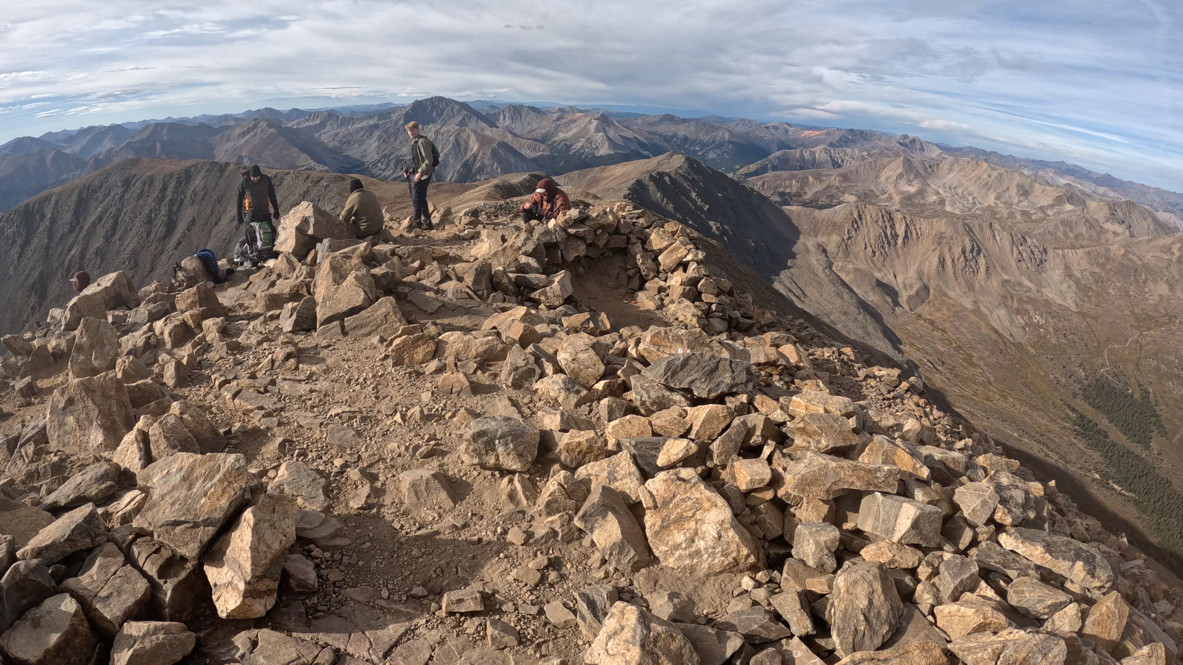
In 2022, my son Daniel (then 16 years old) and I decided to hike Mount Elbert, the highest mountain in Colorado and the highest mountain in the Rocky Mountains at 14,440 ft. We began the hike a bit later than we intended (arriving at the trailhead at 7AM), and made our way to near the summit at almost noon.
When we were achingly close to the end (around a quarter mile and about 100 vertical feet) we were forced to turn around due to gathering storm clouds and visible lightning. Daniel pointed to the summit, only a short distance away and said “It’s right there!”, but I would not relent in refusing to allow us to finish the hike.
“The mountain will still be here”, I said, “but if we continue we may not.”
This year, we decided, would be the year we would officially stand atop the highest point in Colorado. But not just Daniel and I. We decided to make it family hike as part of a summer camping trip in July.
But just days before we were to depart for that July trip, the trail was closed due to the Willow wildfire that was burning in the Leadville area. It appeared that Elbert and the highest point in Colorado would remain a goal for yet another year.
Then as September rolled around, Daniel and I decided to just take a Saturday and go. The wildfire was out and the trail was open. The weather conditions were good. Why wait another year?
So we made a late Friday night drive to Leadville and spent about four hours sleeping so that we would not fail to be on the trail by 5:30 AM.
Despite the hastiness of our departure, I made sure we had everything we could possibly need to ensure success. Rain jackets, headlamps, hiking poles, stocking caps and gloves, first aid supplies, extra sunscreen, and plenty of snacks and water. We were not going to have a reason to have to turn around if I could control it. Our backpacks were a bit heavy, but we could handle it.
We started the hike in the darkness using headlamps to find our way. Starting in the dark was always our plan. If we could make it to the summit mid-morning there was even less of a chance that afternoon rain might turn us around. And Colorado mountain weather in early fall is notoriously unpredictable. A sunny day can change in an instant.
We saw the sun rise just as we arrived at timberline. Timberline in Colorado always seems to occur at 12,000 ft, which I find an interesting biological/geographical rule of thumb. My watch altimeter marked 12,000 as we took a brief moment to admire the sunrise and eat some of our breakfast snacks.
It was now 6:30 AM. Having covered the two fairly steep miles in 1.5 hours, mostly in the dark, we were perfectly on schedule. But the next 3 miles were going to be much more challenging.
Continuing onward, we made relatively good time and were at 13,000 feet. Once past 13,000 feet, the thin air really becomes a factor and progress slows considerably. I call it the “Go Slow Zone”. Ten steps, catch your breath, ten more steps, catch your breath again….
At about 8:45 AM, we finally arrived at the top of a false summit where the actual summit came into view. It was the very spot where we had turned around in 2022. But unlike 2022, storm clouds were still hours away and the path the the summit was right ahead of us.
It took only about five minutes to reach the summit from that spot. It only added to the feeling of disbelief over how close we truly were. But a least we could now say we were standing on the highest point in Colorado.
We had arrived on teh summit at about 9:00 AM, taking only 3.5 hours to achieve the summit. Not an easy task. Literally no one passed us on the way and we passed dozens of other hikers.
But we were feeling the exertion a lot more. The drive to finish the hike and reach the summit had led us to make the 4,500 foot vertical ascent faster than we would normally go. And truthfully, we were feeling it.
Starting down, we began to really appreciate just how steep the trail really is, something we had largely ignored on the way up. The poles helped steady us, but our knees began to tire. Finally, near a rock pile at 13,000 feet we took a genuine break.
I found some ptarmigans amid the rocks and as the first photo indicates, their plumage blends in amazingly well with the surroundings. We took time to eat more of our remaining snacks an rested a good while out of the wind, with several miles yet to descend.
It took another two hours to finally return to my truck as we slowed to a more leisurely pace in the forested area near the trailhead.
My watch said 12:30 PM when we finished the hike. We were unusually beat. The hike provided great scenery and we had accomplished our goal, but we had really pushed hard and were aching more than we had in 2022. Perhaps some of that is the four years I’ve aged since then, but Daniel was feeling pretty exhausted as well.
Daniel and I had lunch together in Leadville and contemplated what our next goal might be. Another 14er? Or a chill lake hike with the family? Whatever it may be, it will be great. And we’ll take our time.
We woke up after a third and final night at Under Canvas Mount Rushmore and were glad to be leaving for a new destination on our last night of the trip.
I went to the showers early and noticed that the towel bin was barely stocked. I grabbed one for myself and proceeded to take another uncomfortable, one-handed shower. After finishing I walked back to the tent to begin packing up and carrying luggage out to the car.
When Shelley and Evan went to take showers, there were literally no towels left. At 7:30 AM. Add that to the fact that two of the shower stalls were out of order and you get the overall level of attentiveness and upkeep that the resort was offering.
I was going to walk up to the host tent and let them know that there were no towels (and to also convey the unfortunate fact that they were doing a really crappy job running the place), but Shelley and Evan just wanted to get going. They would get a shower later in a more comfortable place.
So do we recommend Under Canvas Mount Rushmore? Heck no.
We pulled into Keystone and decided to check TripAdvisor for a list of breakfast restaurants. We had a bit of a drive that day and checked what was available along the route. We stopped at one in Rapid City.
Rapid City
We chose Millstone Family Restaurant which was pretty crowded, but also pretty good. It was Father’s Day and there was a short wait to get seated, but once we did, we had everything we needed (pancakes, eggs, bacon, etc) to start out our day.
After breakfast, we started northwest on the I-90 toward Spearfish and from there we would be continuing on to Devils Tower.
Spearfish
Northeast Wyoming is sparsely populated and there are few options for gas and food. Thus, we made it a point to stop in Spearfish first for gas and coffee. I had spurned the black coffee available at Millstone in favor of trying out a coffee house in Spearfish.
I was definitely curious to see Spearfish since it seems like the kind of small town that has all the right things going for it: a historic downtown with modern eateries and businesses, proximity to the outdoors, and easy access to Rapid City and the I-90 corridor.
I liked the town right away. And the name of the town is cool.
We stopped at Blackbird Espresso which was clearly a popular spot among the locals (who were an interesting mix too). The coffees took a few minutes, but they were good. I always like visiting local coffee shops when we are out on the road.
After getting some coffee it was time to drive west toward one of nature’s most bizarre geologic wonders: Devils Tower.
Devils Tower National Monument
We visited Devils Tower in 2013 when Evan was in a stroller, so for him it was like the first time. I wanted to come back and see it for the third time in my life (my first visit was in 1988 as a school kid).
Driving in we had to wait about 45 minutes just to enter the parking area because traffic is metered to avoid congestion. We were in no hurry so it wasn’t a problem, but do expect delays in the summer months.
The tower is one of those sights that you just can’t believe is real. It just rises as a massive cylinder above the surrounding countryside.
The tower is the remnants of a volcano that once stood in place of the tower. The tower is a volcanic plug of solidified basalt that formed in the neck of the volcano. When the rest of the volcano eroded away, the basalt column remained.
There are two loop trails around the monument from the visitor center. The inner loop is a paved path of about a mile that circles the monument and offers views throughout. However, it is much more popular with visitors and doesn’t explore the surrounding landscapes.
The other option is the 2.5 mile Red Beds Trail, which I elected to take as an alternative hike. Shelley’s knee was bothering her from bicycling the prior day, so I hiked it alone, while Evan and her did the inner loop.
The Red Beds Trail
To access the Red Beds Trail, simply take the marked detour off the inner loop trail near the visitor center. The trail deviates away from the crowds and you’ll soon see that there is more to Devils Tower National Monument, including the Red Beds.
The attached videos show two locations on the trail, the first about one mile from the trailhead, and the second passing through the Red Beds section.
Both loop trails return to the visitor center parking lot so it is easy to rendezvous if you have hikers on both trails simultaneously.
After completing the hike it was time to drive back to Spearfish for some Father’s Day lunch.
Spearfish
Once back in Spearfish I routed us to a place I had found on TripAdvisor before our departure: Sawyer Brewing Company. The description was just exactly what I wanted, a place that served food and drinks with a nice view.
Well, unfortunately it was raining so the crowd was packed together inside. And that made the interior loud and crowded. Not quite what I wanted.
Add to that meh pizza, and meh service, and too much noise, and pushy people seated behind us, and it was not quite great overall.
Before heading down Spearfish Canyon for the final stop of the day, we stopped off at Walmart for some supplies. Spearfish Canyon is pretty, but there aren’t many services available.
Spearfish Canyon
I had never heard of Spearfish Canyon before researching this trip and I’m glad I found it. It’s yet another scenic area of the Black Hills, but one that is a bit more tucked away and quiet.
We first stopped at Bridalveil Falls which is an easy pull-off stop on the road. There are many Bridalveil Falls in the US, including the one in Yosemite.
Unfortunately this one was lacking the water volume it might have had in a snowier year and was therefore, not quite as impressive as we hoped.
But don’t worry, the falls and the views in Spearfish Canyon get better the further south you drive.
When autumn arrives in Colorado, we love to visit the high country to enjoy the vibrant colors that light up the mountain sides. One of the best places to enjoy the leaves of gold is Rocky Mountain National Park.
My 19-year-old, college student son Daniel and I spent the prior night in Estes Park, right outside Rocky Mountain. I had planned out the trip in advance and got Bear Lake Road reservations on August 1st, the moment the reservations become available for dates in September (they are gone within minutes for weekends in the summer and fall). We stopped briefly to get some gas and a quick bite of fast food breakfast, then entered the park at first morning’s light.
After passing the checkpoint to verify our access reservations we drove up to the parking area near the Glacier Gorge trailhead (which leads to Sky Pond), but unsurprisingly the small parking area was already full. We then continued onward to the much larger Bear Lake parking lot further up the road and found it was already completely full as well. We were far from the only early morning hikers ready to enjoy the fall colors.
On the drive up I saw a small parking area just below Glacier Gorge and told my son to drive back down to it, hoping that there would still be a place left there while cars passed us heading up to the full lots above. Sure enough, there was a spot left for us at this little parking area about 3/4 miles below the trailhead. A little extra hiking wouldn’t hurt us a bit.
We started down the trail and made fairly good time as we passed by Alberta Falls in the first mile, then The Loch at about 3 miles, the first of the lakes along the way to Sky Pond.
The trail passed alongside The Loch and after another mile we arrived at the point where the trail becomes a bit more challenging. You must climb a small cliff alongside Timberline Falls with cold water tumbling onto the rocks along the way. We made it fairly easily to the top of the cliff where we were rewarded with the sight of The Lake of Glass.
Many hikers mistake the smaller Lake of Glass for Sky Pond, but the trail continues onward past some boulders that obscure the path at the outset. Following alongside the Lake of Glass we ascended a bit further to arrive at Sky Pond.
With the jagged Shark’s Tooth piercing the sky above the lake, we knew we had arrived. Years before, when he was a seventh grader, we had tried the very same hike but had been turned back at deep snow at Timberline Falls. This time, at the right time of year, we had succeeded and could cross this bucket list Colorado hike off our list.
On the hike back we saw some pika hiding amid the rocks and some trout swimming casually in the Loch. The weather was pleasantly warm and and we would be well ahead of any afternoon rain that might move in.
It was a pretty easy-going hike for the both of us, and a good way to usher in the fall.
Our last day of the trip we had intentionally left fairly open as far as our itinerary. We had gone to the visitor center the day before and saw that there was a ranger-led hike at Taggart Lake on the southern end of the park at 9AM.
Since we had never been to Taggart Lake this seemed like a good activity for the morning. The ranger-led portion was just to the lakeside for about 2 miles. Then we could continue on our own to complete a 4 mile loop back to the trailhead.
Instead of the usual cereal and protein shakes in our cabin, we decided to have a hot breakfast at John Colter’s Ranch House. It was a nice change of pace on a less busy day. Yes, we save quite a bit of time and money by not dining out every meal, but sometimes it’s good to have pancakes, eggs, and bacon.
Taggart Lake
It was about a 45 minute drive from Colter Bay to the Taggart Lake trailhead (with another stop for air in my right-front tire). Once we arrived we waited for the ranger to appear along with the rest of our group then started the guided hike.
It was a bit windier and chillier early in the day as a cold front began to move into the area. That was ok though, it was still a very nice day and we had just gotten really lucky to have such ideal weather the whole trip.
As we made our way along the route the ranger would ask questions of the group. We answered most of them. And he had no qualms about letting us answer them all :).
We’ve been teaching our youngest to not feel embarrassed about ‘showing off’ his knowledge and intelligence. Some kids at school made him feel awkward in science and other class for being a nerd or know-it-all. Let them feel stupid all day long.
So we answered the name of the plant with the yellow flower as ‘arrowhead balsamroot’, that grizzlies love to eat moths, and every other assorted question the ranger had. We also walked into the forest off trail with the permission of the ranger to remind us to take time to let our senses appreciate nature free of all the noise and distractions of life.
As we continued from the lake shore around the loop we saw plenty of vistas of the Tetons, wildflowers, and butterflies, but no significant wildlife.
The Taggart Lake area leads upward to many more trails that I might try in the future such as Delta Lake.
Jackson Hole
I know the town is called Jackson, but everyone calls it Jackson Hole. Which sounds cooler.
We decided to have lunch in JH since we were fairly close to the south entrance and hadn’t been in JH since 2010. Back then we stayed in Jackson, which I realized was pretty distant from the park’s main areas and a bit unsatisfying if you want to enjoy the park.
Jackson has changed a lot in the past couple decades with all the billionaires moving in. We drove past the city park with the elk antler arches (which are pretty cool) and parked on a side street.
We decided to eat at the Merry Piglets because we wanted Mexican food. I had heard of the Merry Piglets because of a famous, recent missing person, murder case that ended in the Tetons not long ago. But regardless of that sad notoriety, we just wanted some burritos.
My food was lukewarm when served, and Shelley’s and Evan’s was almost cold. We sent their food back. I was too hungry to stop and think that my food should have been warmer. They got their remade dishes, which were correctly piping hot. But overall, I can’t really recommend it.
After eating we drove back north into the park and along the way we saw a bison herd. Plenty of junior bison as well.
That was pretty cool and made up for a lackluster lunch.
Colter Bay
We drove back into Colter Bay and parked at our cabin. We wanted to go to the two-mile loop trail that leads to a peninsula off of Colter Bay and afterward we could visit the gift shops one last time.
Shelley and Evan had hiked this trail the day before and were able to point out many things along the way, such as the bear claw marks on a tree (a warning to other bears) and some frogs lurking the mud near the Jackson Lake waterline.
Wile we were hiking back a few people told us a black bear was just seen crossing the path where we were walking. But unfortunately, we missed it.
We walked over to the general store to get some ice cream and met an unusually unfriendly, odd looking guy behind the counter. Almost all the staff we met working at the resorts were nice. This guy was not. Oh well.
We stopped at the visitor center and while inside we heard that the juvenile grizzly had just run past the marina. We stepped outside and there was a crowd there, as well as some rangers at the far end of the marina path. The grizzly was in the woods and the rangers seemed to want it to continue going in that direction.
Well, I had seen bears 6 days of the trip, but so far had struck out today.
We returned to the cabin to start packing up in preparation for departure the next day. We rested a bit, then at dinner time made our way over to the Ranch House again for dinner. It was good and we like it. As far as national park eateries go it’s a good place.
Day 9: Tetons and Wyoming
The next morning I got up early to do the morning hike around the loop trail, hoping to see some wildlife along the way. It was a very chilly 30F degrees and other than the random squirrel or bird in the dim light, the animals were not out and about.
I finished reloading the truck and walked to get some coffees at the coffee shop in Colter Bay. It’s always nice to start a drive with some good coffee. And it helped warm my hands after the biting chill of the hike. The weather had certainly changed overnight.
We left Colter Bay and made one last stop at a pullout before exiting the park.
We’d had a great trip and enjoyed ourselves. But we could still stop along the way at anywhere that looked interesting.
As we were ascending Highway 287 to cross the continental dive, it started to snow. June can still be winter in northern Wyoming.
As we made our way back down toward Dubois, Wyoming the temperatures increased and we were back in summertime.
Entering Dubois we saw a sign for the National Museum of Military Vehicles. Sure. Why not?
The National Museum of Military Vehicles
This museum blew us away. We were thinking we would have an hour stop and peruse the museum like most any other. Instead, after two hours we still weren’t done.
The museum is absolutely huge and full of historical military vehicles, rifles, and everything else related to American military history. It is laid our in chronological order and delves into the experiences of war at places like The Battle of the Bulge in WWII, in Korea, and Vietnam.
Included in the exhibits are German, Soviet, Japanese, and Chinese equipment from the various theaters of war. It was fascinating to see and we wondered how this immense, impressive museum had remained under the radar since it apparently opened in 2020.
Whatever the reason, this museum is a definite stop to make in Dubois, Wyoming.
I will be make a video of the museum and will be posting it here when it is ready.
After the museum we were pretty far behind schedule and needed to make up some time on the drive back.
We tried to get coffee again at the Buffalo Bean in Casper, but it had close for the day by the time we arrived. We had to settle for coffee at the travel center down the road (not as good but decent).
Final Thoughts
We really enjoyed this trip overall, and it was a good change of pace back to a roadtrip after several years of plane travel. I was also glad that we gave ourselves a few more days and this made it a bit more relaxing, allowed us to see and do more, and never feel rushed.
I always have a number of goals for a trip and this trip really met and exceeded in everything we hoped to accomplish. We saw more wildlife than I could have hoped for and all the major ones (bears, moose, wolves, etc). We completed all the hikes that we had planned out. We used our new cooler and hiking equipment to save time and money and to improve our overall experience. We got great photographs and video footage. We did fun activities and still left some places and activities for future visits.
I don’t know when we will be back, but it won’t be six full years again. These parks are only 1-2 days away and I’d be curious to visit in the fall even if visitor services are starting to close for the season. I’d definitely return in June though.
In Colorado there are four national parks and numerous national monuments, historic sites, and recreation areas. Florissant Fossil Beds is a small national monument in central Colorado, just west of Pikes Peak.
Florissant Fossil Beds is a unique and enjoyable place in a relatively quiet spot in Colorado. This December we made our second ever visit to the monument and saw that it had a new visitor center and a more expansive trail system.
We were last at Florissant Fossil Beds in 2012. At the time Shelley was pregnant with our youngest son Evan, who was born in December of 2012, almost exactly twelve years prior to our most recent visit. For Evan, this was his first real chance to visit the monument even though he was phyically there the last time 🙂
We found that in the intervening years a nice new visitor center had been built and we took some time to peruse the exhibits inside, learning quite a lot about the history of the monument and the many fossils that have been found at the site. We learned for instance that more butterfly fossils have been found at Florissant than anywhere else in the world.
Once we stepped out of the visitor center we made our way to the primary attraction that makes Florissant famous: the great, fossilized redwood stumps.
Redwoods?
Yes, Fifty million years ago the climate of central Colorado was warmer and more humid, though the elevation was still quite high. The climatic conditions allowed huge redwood forests to thrive in what is now a dry, alpine environment.
The redwoods were fossilized by a volcanic eruption that happened about thirty miles from the current site of the monument. That volcano is now extinct, but the ash fall that accumulated at their base ensured that the stumps would remain to the present day.
There are several redwood stumps to be seen within a one mile perimeter of the visitor center. Two are only about one hundred feet away, covered by the protective roof. One of these is a triple trunk that originates from a single base.
To see the others, we took a leisurely stroll along the one mile Petrified Forest Loop Trail. Along the way is the most famous of the stumps, called the “Big Stump”. This stump still bears the rusted remnants of a saw blade from a century old attempt to cut into it. Fortunately that attempt failed and the stump remains for our enjoyment today.
I highly recommend visiting Florissant if you are in this area of Colorado. It’s quiet and relaxing compared to many of the more famous attractions in the state and quite interesting. For us it was also kind of fun to bring Evan there so close to his birthday to reminisce and give him the chance to appreciate the park.
Colorado has many terrific national park sites and we decided to try our best to visit as many as we can in 2025. We think we can visit all four national parks in 2025, and we’ll hit many of the national monuments as well. We’ll share our journeys as we go.
This past August weekend I decided I needed to do a bit of Colorado mountain hiking before the short season ends. August is the prime month for 14er hikes since the weather is warm and the snow cover has almost entirely melted off of the peaks.
I didn’t have time to make a multi-day trip so I decided to return to a peak that I hiked back in 2018: Quandary Peak. Quandary Peak is located just south of Breckenridge and is the 13th highest peak in Colorado at 14,265 feet. It is probably the most climbed 14er in Colorado due to its accessibility and relatively short 6.5 mile round-trip trail distance, but its still a good challenge with a 3300 foot elevation gain.
The last time I did this hike there were numerous mountain goats nonchalantly hanging out near and on the trail. The presence of the goats is another factor in the trail’s popularity. Unfortunately on this hike the mountain goats were nowhere to be seen. Pikas, however, were abundant, as you can see in the photos below.
Also, having completed six 14er hikes now, I’ve never encountered wind as strong as what I encountered on this hike. A very strong westerly wind was blowing right down the trail and really added to the difficulty. The prior time I did the trail the wind was minimal and it was much easier, even if a light snow was falling at the summit.
In October of 2023 we took a road trip to Oklahoma and Arkansas. It was part family visit, but also a chance to see a part of the country which was entirely new to us. We had a good time overall, with a few surprises along the way.
As you can see from the map we traveled through Kansas as well, but due to time constraints we weren’t able to see any sights in Kansas, though we did spend two nights in the Sunflower State along the way. Don’t worry though, we’ll travel that way again in the future and give Kansas a closer look.
Day 1: Tulsa and Owasso, Oklahoma
Evan in the Gathering Place rope course
Our primary purpose in visiting Tulsa and Owasso was to visit family. But we did venture to Tulsa’s Gathering Place park. The Gathering Place is a huge urban park full of fun outdoor activities for kids and adults. My kids really enjoyed the very, very vast playground attractions which cover many acres.
We walked around the park, enjoyed the koi at a lake, traversed the many trails, enjoyed the nature and bought some ice cream and drinks. This is a good place to go to spend some free time while in Tulsa. The park has free admission too.
Day 2: Owasso, Oklahoma to Hot Springs, Arkansas
The second day was one that would involve a number of stops as we traversed a portion of the Talimena Scenic Highway to Queen Wilhelmina State Park, Mena Arkansas for lunch, the Crater of Diamonds (a longtime interest for the family, and ending at our hotel in Lake Catherine outside Hot Springs.
Queen Wilhelmina State Park
Overlook at Queen Wilhelmina State Park
My original plan for our stop at Queen Wilhemina State Park (just across the border in Arkansas on the Talimena Scenic Highway) was to take the short trail to the Lovers Leap Overlook.
Unfortunately when we arrived it was very windy and chilly and we were not prepared for the weather as this short video shows.
So instead we took a few photos from the overlook and made a visit to the lodge and gift shop.
Afterward we walked over to the historic 1920s steam train engine nearby, and then the odd Wonder House, which is a multiple story historic house made of stone that was built in the 1930s.
Somehow this little house has nine stories. You can only look into the windows but you can start to understand that the stories are not conventional ten-foot floors as you would normally expect, but are rather split-level floors at staggered elevations of the house as it sits on a slope.
Mena, Arkansas
Our next stop was Mena, Arkansas which is a small town in west-central Arkansas. It is the end point in the Talimena Scenic Highway and a great place to visit on its own.
I had one place in mind for lunch and it turned out to be as good as advertised: The Ouachitas.
Bar at the Ouachitas
I’ve seen the Ouachitas called Ouachita Coffee Roasters as well, but it’s a pretty cool mix of coffee shop, beer brewery, and pizzaria. The pizza was exellent and if we weren’t heading onward to the Crater of Diamonds I would have loved to have tried the beer and coffee as well. The interior is cool too with a lounge area and long tables for dining. It’s one of the few places that seems to do many different things well.
Crater of Diamonds State Park
I have to admit that my plans tend to be a bit ambitious and time is always my worst enemy. The Crater of Diamonds State Park closes at 6 PM but the diamond mine (the crater) closes at 4PM. So in other words we had to hurry.
Driving in Arkansas is slow going over most of the roads. They are long and windy and traveling 50 miles takes over an hour. When we arrived at the Crater of Diamonds we had less than an hour to dig, but we were not going to miss out. I had packed digging tools with us for the trip just to dig for diamonds.
Evan and Daniel digging in Crater of Diamonds
The garden tools turned out to be pretty good at turning over the hard soil quickly. The best tool was actually a weeding tool that I could push down into the hard surface soil to break it up.
We found some quartz and jasper and brought home a few rocks that we found interesting. I’ve heard there can be diamonds within the rocks so we may break a few open to see if there are hidden gems.
Despite the rush, this was a fun stop for us and we made another stop at a gift shop to add to my shot glass collection.
The drive to Hot Springs from Crater of Diamonds was a bit more relaxed and easy. When we arrived at the Staybridge Suites at Lake Hamilton (just south of Hot Sprinsg) we had a two room suite and two days to relax a bit after the rushed day of driving and site-seeing.
Day 3: Hot Springs National Park and Garvan Gardens
I have to admit that our first impression of Hot Springs was a bit underwhelming. The town south of the national park appears a bit run down and congested. On arriving in the historic town we saw a lot of buildings that appeared to be historic but many were in a vacant state of disrepair.
After finding a place to park in a parking garage just off the Bathhouse Row, we ambled down to the Pancake Shop, another often-recommended restaurant that we fit into our itineray.
There is no shortage of food at the Pancake Shop and the food is delicious. I ordered the Deep-Fried French Toast with eggs and bacon. It’s a little more expensive than typical breakfast restaurants but I still think it’s a good morning breakfast before exploring the national park.
Hot Springs National Park
Hot Springs National Park is an unusual national park considering it focuses on historic bathhouses and has a relatively small natural area amid an urban setting. But that has a lot to do with the history that surrounds its establishment.
Long before the idea of national parks existed in the 1830s the hot springs of Arkansas were considered a place of special importance. The United States government under Andrew Jackson decided to create a “Hot Springs Reservation” to protect the hot springs. The town grew up alongside the reservation.
When the national park service was established and the first national parks were established, Hot Springs Reservation was absorbed into the park system as Hot Springs National Park. Unlike most national parks the focus is on man-made structures and history, but the natural features (primarily the hot springs) are well worth seeing.
Our first stop was to the hot springs on the Grand Promenade. But before visiting the bathhouses we wanted to hike up to the mountain tower. It was a short uphill hike on the Peak Trail as you can see in the video.
I decided to take the stairs up to the tower museum and viewing area, which was a bit of an added challenge but there is an elevator to the top. The views of the surrounding mountains and bathhouse row are pretty impressive. You’ll learn a lot more about the history of Hot Springs and it’s importance to the early days of baseball in the museum.
After hiking back down from the mountain tower we walked the Grand Promenade to the Bathhouse Row. The bathhouses are an amazingly beautiful representation of Gilded Age luxury and we walked through the Superior Bathhouse Museum run by the national park service.
Ceiling stained glass in the Bathhouse Museum
Garvan Gardens
After touring the museum we left Hot Springs National Park for arvan Gardens. Garvan Gardens is a huge outdoor garden area operated by the University of Arkansas on a peninsula southeast of Hot Springs.
I have to warn you that Garvan Gardens is not small and really takes a couple hours to fully explore. We walked about through about half of the total park before fatigue started to wear on us from all the previous hiking.
The park is not only full of plants of every imaginable kind but also unique structures and even interesting wildlife, like a green snake. We hoped to see the chapel too but unfortunately there was a wedding going on at the time of our visit.
After a long, tiring day we were ready to eat a good dinner. Since we were also celebrating my birthday the next day I chose the German restaurant Steinhaus Keller. It was great and they brought be a desert cheesecake with a Roman candle 🙂
Day 4: Hot Springs to Eureka Springs
The next day we woke up and had breakfast in the Staybridge Suites before starting off on the slow, windy, but scenic drive north to Eureka Springs. My initial plan was to go first to Mount Magazine State Park, then to Whitaker Point, and then to finish the evening at Eureka Springs where we would also see a magic show at the Intrigue Theater.
So heading north we made our first stop just before noon at Mount Magazine Lodge. My sons and I set off for a hike to Signal Hill which marks the highest point in the state of Arkansas while Shelley called in for a work meeting.
Mount Magazine State Park
We made a video of our hike and as you can see from the video we had a good time. The fall colors were by now really starting to show and that made this trek in the Ouachita Mountains highest point particularly enjoyable.
After returning to the lodge we met up with Shelley and had birthday lunch (for me) at the lodge. The lodge restaurant was meh and if there had been other options nearby I would have considered that instead. Still, the view was nice.
At lunch I decided against stoping at Whitaker Point, which is arguably the most photographed spot in Arkansas. Even had fallen and cut his leg right at the end of the hike to Signal Hill, Whitaker Point is considered a semi-dangerous hike for kids (there have been fatal falls on the trail), and I wanted to get into Eureka Springs a little earlier so we could amble around town and eat dinner before the magic show.
The drive north was on the Pig Trail which is Highway 23. It is a very scenic drive through a forested canopy. The trees were fully at the height of fall colors as I had hoped, but it was still a really pretty drive. Along the way a groundhog crossed the road and I got a quick photo of him as we were passing.
Overlook on the Pig Trail
Shortly thereafter we arrived at the historic town of Eureka Springs.
Eureka Springs
Eureka Springs is one of the major tourist spots in Arkansas and I was looking forward to seeing it. It mostly lived up to my expectations but I did find it a bit difficult to fully grasp.
We stayed at the Quality Inn and I was wise to make reservations early since we would be there on a Friday evening in the fall, the height of tourist season. After we checked in we changed into clothes for the evening and drove into the downtown district.
Family photo in Eureka Springs
The downtown district is very popular and the sidewalks and streets were full of people ambling from one location to another. I was hoping to stop at a restaurant in the town but I found it a bit difficult to find a good place for the family and we ended up driving to a different spot outside the downtown area.
Eureka Springs is a bit eclectic and has a varied crowd. Not every place seems very family-friendly (one place I walked into was the New Orleans hotel which had a 21-and-over sign at the bar). But it is a really cool downtown architecturally and historically so it’s worth walking the very uneven sidewalks and crossing the bridges from one side street to another.
We ended up going to the Rockin’ Pig Saloon. Truth to tell, I was a little disappointed with the Rockin’ Pig despite the good reviews online. The crowd was a bit edgy (two types of people seemed to hold sway in the restaurant and if you were neither than you seemed a bit out of place). The BBQ food was good overall but the service was also overwhelmed by the number of people in the restaurant. It was a bit disappointing too since it was my birthday.
After the dinner, we drove quickly back to the hotel before going to the magic show at the Intrigue Theater.
Intrigue Theater
I don’t have any photos of the Intrigue Theater but I will tell you that it’s a small old church that’s been converted into a venue for a magic show. The show is really good and with so few people in the audience almost everyone gets to be involved. My son Evan was brought up on stage for one of the tricks.
If you really want to be in the show pay the extra for front row seats. He called on the front row many times more than the rest of the audience.
I figured out how a few of the tricks worked but most of them are really baffling. I highly recommend it.
Day 5: Eureka Springs to Haysville, Kansas
The next day would be a drive back to Oklahoma for another visit with family, followed by an evening drive to Haysville, Kansas for the night. I truthfully had trouble sleeping and woke up at 4 AM to walk outside and took this picture of the Orion Constellation over the forests by the hotel.
After finally returning to the room for a last few hours of sleep and a pretty good breakfast at the hotel, we started west from Eureka Springs toward Owasso, Oklahoma.
There was one stop I really wanted to make sure to do before we left Eureka Springs and that was to the Thorncrown Chapel. Fortunately the fall colors were really taking hold by now and I was able to get some nice photos of the chapel at its seasonal best.
Thorncrown Chapel
The chapel is right off US 62 west on the way toward Bentonville so it was an easy stop on the drive. It was nice and peaceful and well worth the stop.
After the chapel we continued on our way back to Oklahoma. I had one more stop in mind before we arrived back in Owasso to visit with family. The Natural Falls State Park in Oklahoma.
Natural Falls State Park
If there was one place that truly exceeded my expectations it was this state park in Oklahoma. I hadn’t read much about the park and my older brother who lives only an hour away had never heard of it. But we found the scenery and the trails there to be very nice. The falls and the grotto of dripping water along the cliff face were stunningly pretty.
The attached video shows our exploration of the park. This time Shelley was able to accompany us as we went low and high to see the falls and surrounding nature.
After the falls we headed onward finally ahead of schedule to visit with family and we did have birthday cake at my brother’s house. It was a nice visit, including testing out his swimming pool.
Finally we drove onward through the Osage Reservation north of Tulsa to our final stop in Haysville, Kansas.
Day 6: Haysville, Kansas to Home
I was hoping to stop off at a museum or two on the drive back through Kansas. Unfortunately,, it seems most everything along the way is closed on Sunday and we had limited time to make the long drive. Kansas, we will be back and see you in more detail.
Overall it was a good trip. I do feel that all the driving was a bit exhausting especially in such a short amount of time. Covering 1400 miles in a week is a bit exhausting. Additionally, I would have liked more time to relax and see more in places like Eureka Springs, the Arkansas Ozarks, Oklahoma and along the way in Kansas.
So I’m going to back off for a little while on long road trips and focus more on shorter drives and flights to locations. Having your car is nice however as you can be as spontaneous as you want and don’t need to worry about returning a car.
I had never been to Arkansas and it was nice to finally see this last of the states west of the Mississippi River that I had never visited. Additionally I had only just barely been to Oklahoma and that was just across the western panhandle in 2018. Finally, it was good to see Kansas again after 23 years. It was almost as though the entire trip was one of new discoveries.
I have a new hike to add to my list of The Greatest Day Hikes in the USA. The DeCaLiBron Loop is a 7.6 mile hike that leads to the summits of four of Colorado’s 14er mountains. The trailhead is located at Kite Lake, which is up a 4-wheel drive road from Fairplay, CO.
7.6 miles isn’t usually that difficult, but the elevation changes as you summit one mountain, descend and reascend the next one make it challenging. My teenage son and I were both pretty tired after completing the hike.
You can complete the hike in either direction, starting with Mount Democrat, then continuing to Mount Cameron, Mount Lincoln, and finally Mount Bross. Or you can do them in reverse, as we did. I don’t think there is an advantage in going in either direction, but the scenery might be better going in the reverse direction.
There are a couple things to know in advance before starting this hike. The first is that once you start it and advance past the first summit there is no quick return to the trailhead. Thus you must keep an eye on the weather and start early to avoid afternoon thunderstorms. We saw people arriving at 10AM and hopefully they weren’t trying to hike more than one mountain.
The other thing to know is the trail and the mountains themselves are on private land. Because of a recent lawsuit private landowners are reluctant to allow the public to use trails on their land. Fortunately the landowner is allowing the public to use the trail as long as they complete this online form the day of the hike: https://waiver.smartwaiver.com/w/c2d3wpisftzvbznpjhsbnb/kiosk/ .
My son and I battled through the wind and cold, the altitude, steep terrain and later the heat and loose rocks to complete the loop. Overall it’s something to be proud of once you finish it.
Despite living in Colorado for 12 years, we had not yet driven up the Mount Evans Scenic Highway as a family. With summer winding down I decided it was time to finally do this before winter set in (the road is only open a couple months each year in the mid to late summer).
I had once before taken a drive up to the summit with my older brother all the way back in 1997 when I was in college. Now twenty-six years later I wanted to take my family to the top to enjoy the scenery and the alpine wildlife, which frequently includes mountain goats, bighorn sheep, marmots, and pika.
We actually had more of an experience than we planned on. We hit a torrential downpour on the I-70 west of Denver that cleared up before we took the road south toward the mountain at Idaho Springs. Then we hit some of the thickest fog we’ve ever driven through. Still, like many others on the road that day, we carried on with a can-do spirit and had a really enjoyable time, even if we couldn’t see for a hundred miles.
We saw plenty of mountain goats and I took the short hike to the very top to get a photo of the very worn survey marker. When the clouds did part we had some fleeting vistas with impressive displays of light and cloud.